![]()
![]()

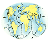
The surface of the Earth is not one piece but cracked, like a broken eggshell, into giant slabs. There are about 2 huge pieces of rock which are called tectonic plates. Tectonic plates are not held in one place, but slide around the Earth. They move very slowly - at about the pace of a fingernail growing. But tectonic plates are o gigantic that their movement has dramatic effects on the Earth's surface. Earthquakes and volcanoes happen where plates slide apart or past each other, or collide. Colliding plates also push up mountain ranges.
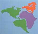
The continents drift around the world on tectonic plates. Once, they were all joined together in one huge continent called Pangea. Around 200 million years ago, the tectonic plates beneath Pangea began to move apart, carrying fragments of the continent with them. These fragments slowly drifted into positions they are in now.
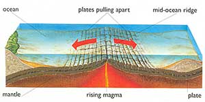
Right down the middle of the sea bed in the Atlantic Ocean, there is a giant crack where the tectonic plates are pulling apart. Molten (melted) rock from the Earth's interior wells up into the crack. As it cools, it solidifies (becomes solid) to form the mid-ocean ridge.
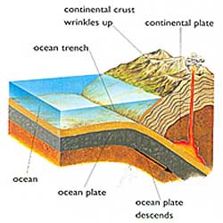
In many places, tectonic plates slowly crunch together with enormous force. As they collide, one plate may be forced under the other. Earthquakes and volcanoes are often the result.
The experiment demonstrates how the continents may have once been, and how they move.
You will need :
1) Atlas
2) Pencil
3) Sheets of colored card
4) Scissors
5) Paper clips
6)Two boxes.
Step 1
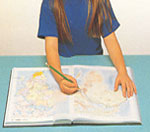
Find the continents of North and South America, Europe, and Africa in an atlas. Trace the outlines of the shape of these continents onto tracing paper.
Step 2
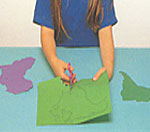
Stick the tracing paper on to different colored sheets of card. Then carefully cut around the outlines of the continents you have drawn from the atlas.
Step 3
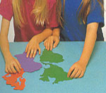
Move the eastern (right-hand) coasts of North and South America up to the western (left- hand) coasts of Europe and Africa to see how well they fit together.
Step 4
You will find that the coastlines of the Americas, Europe, and Africa fit together very well. Scientists believe that these continents were once joined together in these way.
Step 5
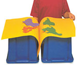
The continents of the Americas, Europe, and Africa sit on plates that are moving in opposite directions. Use the continent cards you have made in the above project to see how they drift apart. Fold a large sheet of card in half, and attach paper clips along the fold. Drape it over two boxes. Stick the Americas on one sheet, and Europe and Africa on the other. Push upward on the fold, and see the continents move apart.

Try out the other sections
 Craft Ideas for Kids
 Benefits of Yoga for Kids
 School Projects & Homework Help
 Hobbies